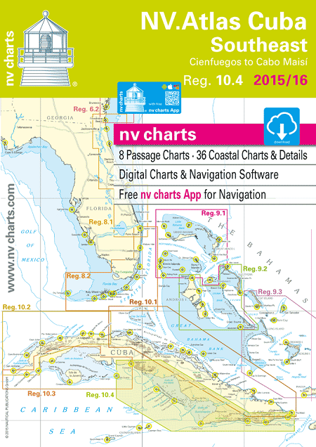
NV Atlas Cuba 10.4: Southeast, Cienfuegos to Cabo Maisi
$108.95
2015-2016 edition
NV Charts · Reg. 10.4: Cuba Southeast · Cienfuegos to Cabo Maisi
In stock
Description
2015-2016 edition
NV Charts · Reg. 10.4: Cuba Southeast · Cienfuegos to Cabo Maisi
- Includes Harbor & Anchorage Charts
- 8 Passage Charts – 36 Coastal Charts & Details
- GPS Charted Waypoints
- Size (Closed): H (16.5″) x W (11.7″)
- Format: Kombipack Paper / Digital download and App
The NV Charts are characterized by fine contours and easy to distinguish color graduations of the depth lines – turquoise for coral reefs, red for the 2-meter-line and blue for the 5-m-areas. Presented in a handy, user friendly size, a thick plastic envelope protects the charts, enabling them to be easily stored.
The importance of good graphical representation of the topography when sailing in the Caribbean is essential. Well marked rivers, towns and street plans all help to give a clear overall view of the shoreside facilities of the islands. Red numbered waypoints with coordinates based on WGS 84 enable yachtsmen to navigate using their GPS instruments. Heights and depths are given in the internationally accepted format of meters. Large scale approaches and land contour markings simplify the entrance into anchorages.
Passage Charts
- C0 Caribbean Sea 1: 6,500,000
- C1 Cienfuegos to Cabo Cruz 1: 900,000
- C2 Cuba Southeast 1: 900,000
- C3 Cienfuegos to Cayo Bretón 1: 340,000
- C4 Cayo Bretón to Cabeza del Este 1: 340,000
- C5 Cabeza del Este to Cabo Cruz 1: 340,000
- C6 Cabo Cruz to Santiago de Cuba 1: 340,000
- C7 Santiago de Cuba to Cabo Maisí 1: 340,000
Coastal Charts
- C8 Ancón to Canal de Tunas 1: 140,000
- C9 Cayo Bretón to Golfo de Ana María 1: 140,000
- C10 Golfo de Ana María North 1: 140,000
- C11 Golfo de Ana María South 1: 140,000
- C12 Golfo de Ana María to Cabeza del Este 1: 140,000
- C13 Cabeza del Este to Banco de Buena Esperanza 1: 140,000
- C14 Banco de Buena Esperanza to Pta. Guá 1: 140,000
- C15 Pta. Guá to Cabo Cruz 1: 140,000
Approaches & Details
- C16 Ancón to Cayo Blanco de Casilda 1: 60,000
- C17 Canal de Tunas to Cayo Blanco de Zaza 1: 60,000
- C18 Cayo Bretón 1: 60,000
- C19 Cayos de Ana María 1: 60,000
- C20 Cayos Cuervo to Algodón Grande 1: 60,000
- C21 Canal del Pingüe 1: 60,000
- C22 Cayos de Manzanillo 1: 60,000
- C22A Canal Cuatro Reales 1: 60,000
- C23 Canal de Madrona 1: 60,000
- C24 Cabo Cruz 1: 60,000
- C25 Bahía de Cienfuegos 1: 40,000
- C26A Cienfuegos Approach 1: 20,000
- C26B Cienfuegos 1: 20,000
- C26C Santa Cruz del Sur 1: 20,000
- C27 Bahía de Casilda 1: 20,000
- C27A Pasa Boca de Juan Grin 1: 25,000
- C27B Estero Boca Grande 1: 20,000
- C27C Estero Vertientes 1: 20,000
- C28A Cayo Blanco de Casilda 1: 30,000
- C28B Bahía de Pilón 1: 30,000
- C28C Chivirico 1: 20,000
- C29 Bahía de Santiago de Cuba 1: 25,000
- C29A Ensenada Marea del Portillo 1: 20,000
- C29B Approach Santiago de Cuba 1: 15,000
- C30 Bahía de Guanatánamo 1: 60,000
- C30A Puerto de Baitiquiri 1: 12,000
- C30B Puerto Escondido 1: 20,000
- C30C Passage Bahía de Guantánamo 1: 30,000
Additional information
| Dimensions | 17 × 12 × 0.2 in |
|---|